
TerraEye vs the AI Exploration Landscape: Turning Satellite Data into Decision Throughput
Let’s state an uncomfortable truth about modern mineral exploration: Very few teams—whether Juniors, Mids, or Majors—are using satellite data to its full potential.
Exploration teams constantly battle a lack of high-quality data. Because of this, data gathering—boots-on-the-ground fieldwork, geophysics, and drilling—will always be the lifeblood of discovery. But a critical shift is happening. As satellite and Earth Observation (EO) data become more accessible, the bottleneck is no longer just getting data.
The real bottleneck is decision throughput.
Most teams can assemble satellite layers, geophysics grids, geochem spreadsheets, and legacy reports into a massive GIS project folder. But too often, satellite data is treated as just a "pretty background picture" rather than a dynamic, mathematical decision layer. What follows is weeks of interpretation churn, inconsistent reasoning between team members, and targets that are hard to defend six months later.
At TerraEye, we are changing how Juniors, Mids, and Majors reach a decision based on their data. We are building a platform around a single constraint:
Every output must survive contact with a real exploration workflow. Data -> dialogue -> decision — with full traceability.
This post explains how we think about the competitive landscape, what we do differently, and why our “product” is not just software.
What TerraEye Actually Sells:
Platform + Adoption Engine
We do not ship “maps.” We ship a system that turns heterogeneous evidence into ranked, interrogatable decision objects. We democratize remote sensing so that your team gets results in minutes, not months.
Critically, every TerraEye subscription includes support, because exploration value is captured in adoption, not in features.
1. Subscription Includes Support
(Not a Ticketing Afterthought)
When a team deploys TerraEye, we assume the real work starts after access is granted. We focus on:
- Aligning the platform to your internal decision gates (screening -> shortlist -> field plan -> iteration).
- Ensuring your targets are reproducible (not “one analyst’s magic”).
- Helping your geologists translate outputs into actionable next steps.
2. Geologist-Prepared Insights as a Service
For teams that need decision-ready deliverables quickly, we offer report generation services:
- All reports are prepared by our in-house geologists.
- We work with P.Geos and Qualified/Competent Professionals (where jurisdiction and reporting standards require it).
- Outputs are designed to be used directly for internal technical alignment, board updates, JV discussions, and field program planning.
Many organizations don’t fail due to a lack of analysis—they fail because the analysis doesn’t land as an operational decision.
The "Forward Deployed Geologist"
(And What It Is Not)
To truly close the "Data to Decision" loop, we’re rolling out a support platform built around a role we call the Forward Deployed Geologist (FDG). This is not “more consulting.” It’s a product mechanism to close the last mile.
What the FDG does:
- Sits with your team (sometimes literally in the same room for weeks or months).
- Maps how decisions are actually made inside your company.
- Integrates TerraEye outputs into your operating cadence and tooling.
- Ensures best-in-class software and datasets become one coherent decision loop, rather than parallel workflows.
What the FDG is not:
- Not a replacement for your technical team.
- Not a one-off interpretation service.
- Not a black-box target factory.
How TerraEye Compresses the Exploration Loop
Our product philosophy is simple: targets must be testable hypotheses, not static anomalies. By focusing on decision alignment, we routinely help clients achieve an Best possible field match for validated spectral targets and make field planning up to 75% faster.
- Masking & “Bare Earth” Discipline: Covered terrain is where targeting systems break. We build Bare Earth Composites (BEC) and operationalize the masking of vegetation, water, clouds, and snow so your team interprets pure geology, not artifacts.
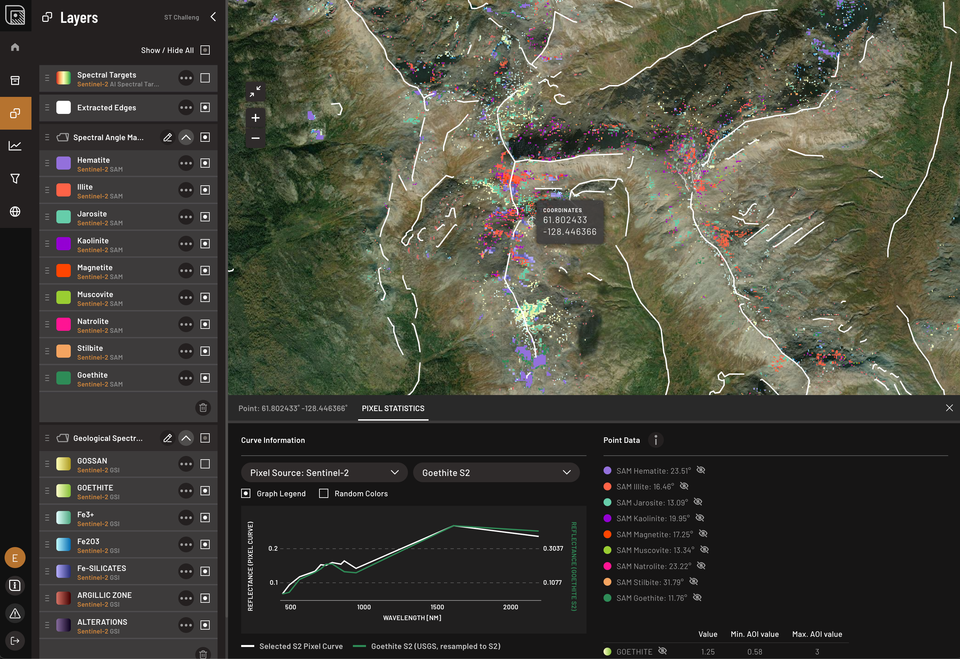
- Explainable Spectral Targeting: We treat targeting as a claim that must be interrogated. Using algorithms like Spectral Angle Mapper (SAM) and Mixture-Tuned Matched Filtering (MTMF), we provide full traceability on alteration signals so geologists can validate or reject the target.
- Covered Terrain Signals: In partially covered terrain, you need auxiliary signals to prioritize corridors. We incorporate signals like Metal-Stressed Vegetation (MSV) responsibly—positioned as prioritization evidence to reduce wasted field days, not a “guaranteed discovery.”
- Agentic Workflows: We generate mineral hotspots as interactive decision objects that are filterable, rankable, and comparable across an Area of Interest (AOI).
The Competitive Landscape: Same Destination, Different Wedges
“AI for mining” is not one category. Here is how we map the market and where we fit:
- AI Targeting Platforms (SaaS for Exploration Teams): * Our stance: We compete here, but we differentiate by providing interrogatable decision objects, extreme preprocessing discipline, and hands-on adoption support (like the FDG program), ensuring outputs don't just become static PDFs.
- Full-Stack Discovery + Drilling Validation (e.g., Earth AI): * Our stance: We don’t compete on drilling. We compete as the decision layer that helps your team retain control and move faster with your own execution strategy.
- Geophysics-Anchored Integrated Stacks (e.g., Fleet Space): * Our stance: We act as the fusion layer. We integrate their geophysics data with our surface spectroscopy models to build a unified evidence base.
- AI-Native Exploration Companies (e.g., KoBold Metals): * Our stance: Not direct competition. You can't "buy" KoBold as a software tool. We give juniors and operators the same AI leverage without requiring them to become an internal research lab.
A Buyer’s Checklist for AI Exploration Tech
If you’re comparing platforms, don’t start with algorithms. Start with adoption and governance:
- Workflow Fit: Can your team interrogate and refine targets, or only consume results? Does it support the full regional ->prospect ->field plan continuum?
- Provenance & Reproducibility: Can you answer “why this target” six months later without relying on tribal knowledge?
- Evidence Fusion: Can you combine Earth Observation outputs with geochem and geophysics while handling contradictory signals?
- Time-to-First-Decision: How fast do you get a ranked shortlist that is field-program-ready?
- Support Model: Is support embedded into adoption, or is it a separate paid escalation path? Do you have access to Qualified Geologists when you need deliverables?
The industry doesn’t need more tools. It needs fewer loops between “data exists” and “a decision is defensible.”
Want to see if TerraEye fits your workflow? The best test is simple: pick a real Area of Interest, bring your existing data, and let's evaluate how quickly you can produce a shortlist that your team is willing to execute—and can defend.