TerraEye Results Delivery

Every few months, we hear the same question — sometimes directly, sometimes between the lines.
We often hear a lot of good things about high-resolution commercial satellite data. So a common question follows: why would we need anything beyond that?
It’s a fair question. And one worth answering properly.
Because in mineral exploration, the problem is rarely a lack of data. More often, it’s a lack of context.
Two Phases, Two Different Questions
At TerraEye, we deliberately separate our work into two analytical phases — not because it looks good in a proposal, but because each phase answers a different geological question.
They are not alternatives. They are complementary.
Phase 1: Understanding What Is There
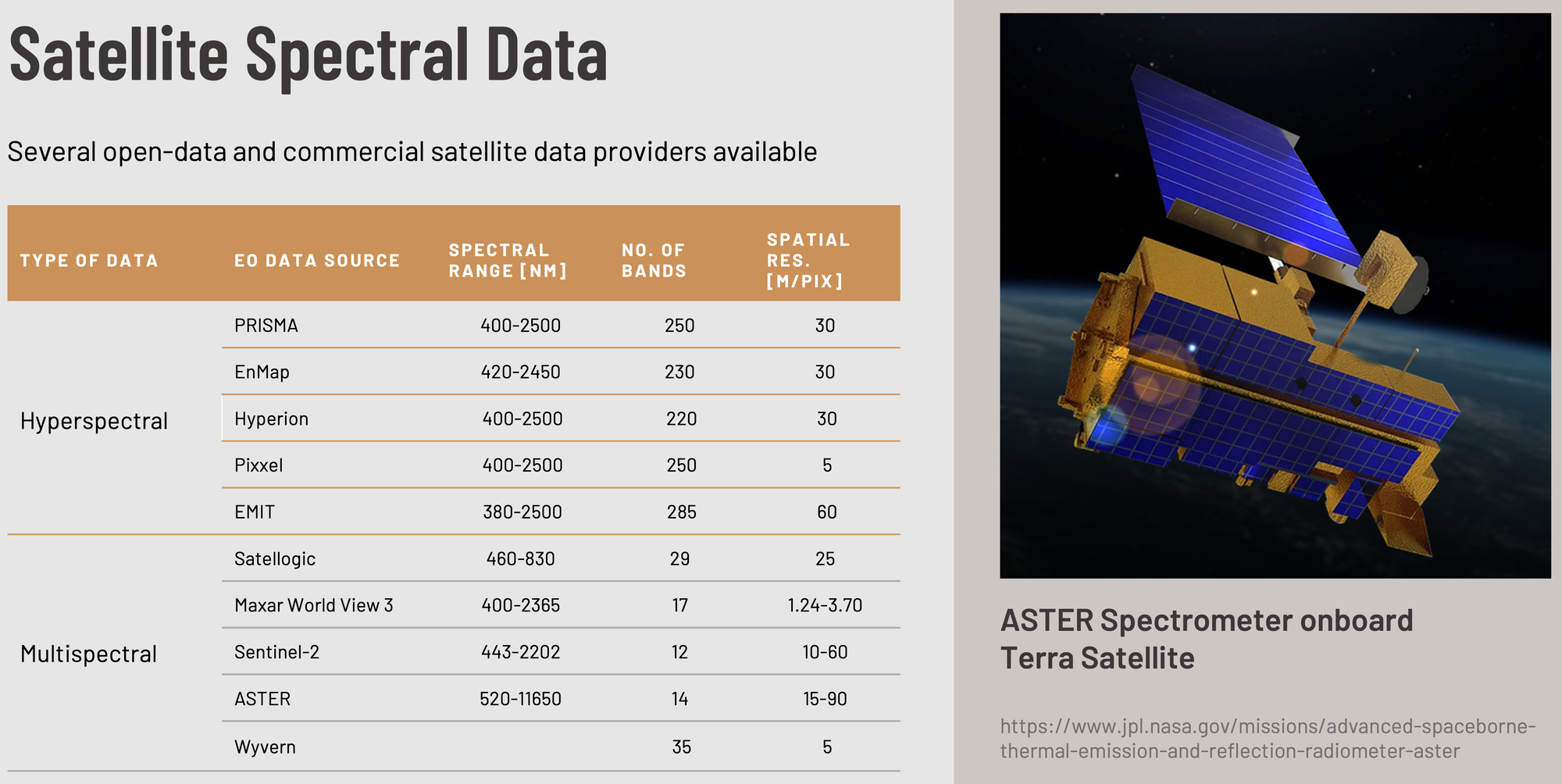
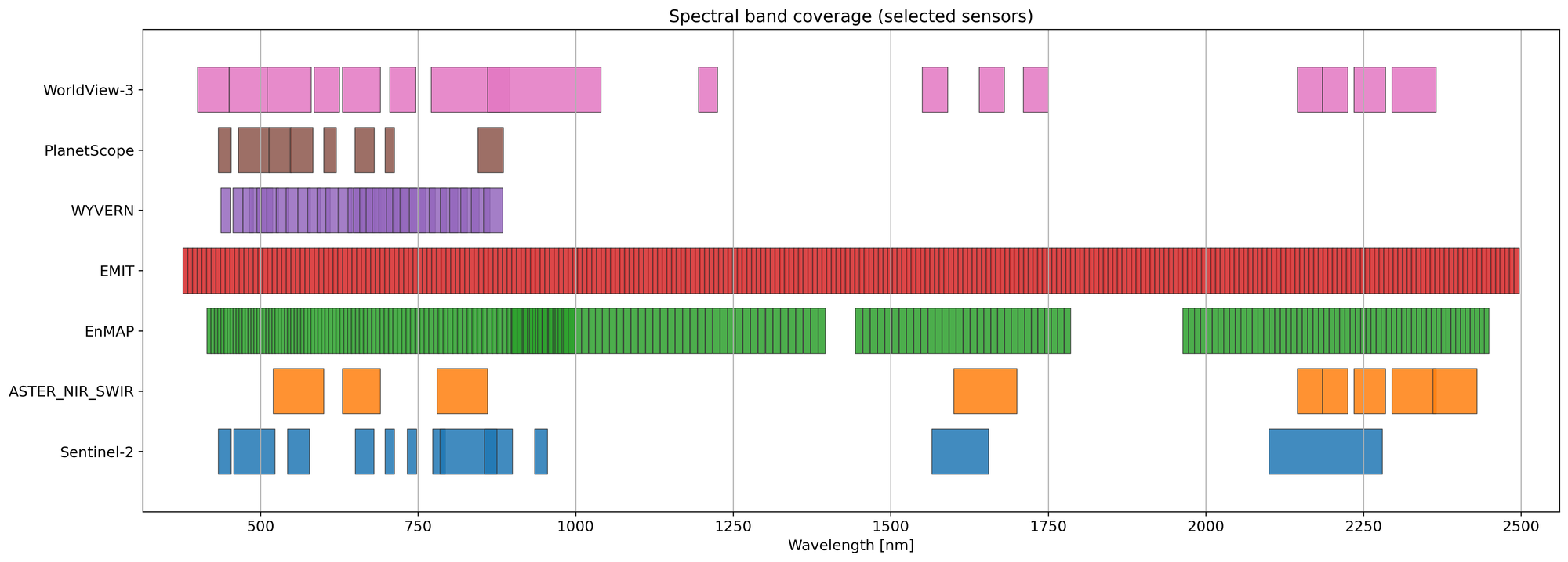
The first phase relies on open satellite data — Sentinel-2, ASTER, EnMAP, EMIT — a combination of multispectral and hyperspectral sensors.
What matters here is not spatial resolution, but spectral detail.
Hyperspectral data allows us to look beyond colours and textures and focus on mineralogy itself:
- distinguishing minerals that look similar in standard imagery,
- identifying consistent alteration patterns linked to geological processes,
- detecting mixed mineral signals rather than forcing each pixel into a single class.
The outcome of Phase 1 is a mineralogical and alteration framework for the area — a geological interpretation that significantly reduces uncertainty before any high-cost, high-resolution data is introduced.
In simple terms: Phase 1 helps us understand what the surface is made of and which processes shaped it.
Phase 2: Understanding Where Exactly
Phase 2 uses commercial WorldView-3 data.
WorldView-3 excels at spatial detail:
- ~1.2 m resolution in VNIR,
- ~3.6 m in SWIR,
- excellent for mapping structures, contacts, textures, and precise boundaries.
But there is an important limitation that is often overlooked.
WorldView-3 has only 16 relatively broad spectral bands.
That means exceptional spatial clarity — but limited mineral discrimination compared to hyperspectral sensors. Without prior mineralogical context, WV-3 analysis can easily drift into over-interpretation and false positives.
This is why we never treat WV-3 as a replacement for hyperspectral data.
Instead, Phase 2 is a targeted zoom-in:
- applied only to areas already identified as geologically meaningful,
- guided by the mineralogical understanding built in Phase 1,
- focused on operational precision rather than discovery alone.
Why This Order Matters
Starting with hyperspectral data is not just a scientific choice — it’s also a cost-optimization strategy.
Rather than ordering commercial data blindly across an entire licence area, Phase 1 allows us to focus high-resolution analysis only where there is real mineralogical justification. WorldView-3 is then applied only where it makes geological sense, not everywhere.
In practice, this shifts budget away from blanket data acquisition and toward higher-quality interpretation, while significantly increasing confidence in the final targets.
One Dataset Never Tells the Full Story
Hyperspectral data answers:
What is the surface made of?
WorldView-3 answers:
Where exactly are the structures and boundaries we care about?
Only when these perspectives are combined do we get a coherent, defensible exploration picture.
The figures below illustrate this clearly… — showing how diagnostic absorption features visible in hyperspectral data are progressively lost as spectral resolution decreases, even when spatial resolution improves.
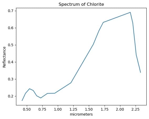
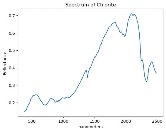
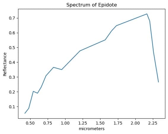
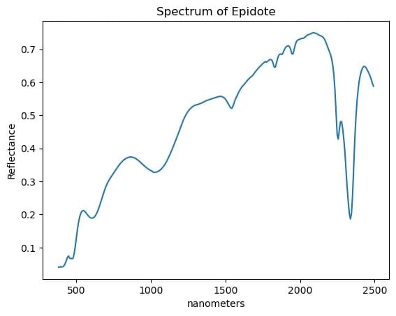
Comparison Mulispectral vs Hyperspectral curves
Final Thought
In exploration, sharper images do not automatically mean better decisions.
Understanding comes first. Precision follows.
And it is the fusion of spectral insight and spatial detail — not one or the other — that turns satellite data into field-ready targets.