
Maximizing Spectral Targeting in Challenging Terrain (Vegetation, Snow, Sand) Part 2
In many exploration regions, the main limitation is partial surface exposure, caused by vegetation, snow, sand, or weathering. TerraEye’s preprocessing algorithms filter out surface interference and enhance true geological signals, reducing false anomalies before spectral targeting.
This ensures spectral target maps are reliable, interpretable, and actionable, allowing exploration teams to confidently prioritize zones for mapping, sampling, and verification — saving both time and budget while improving decision quality.
Our Proven Approach to Tough Terrain
Outcrop Detection (AI-assisted)
Supervised machine learning identifies likely bedrock exposures across your area of interest. Trained on reference samples of rock, vegetation, and other surface types, the models classify each pixel accurately, even in complex terrain. On large AOIs, what could take weeks of manual mapping is done in minutes, providing a reliable outcrop mask that shows exactly where bedrock is exposed. This lets teams focus immediately on the most promising zones, saving time and improving field verification efficiency.
What you gain from this:
- Anchors analysis on actual bedrock, reducing uncertainty in surface interpretation
- Rapidly processes large areas, replacing weeks of manual work with minutes of computation
- Separates meaningful targets from vegetation or surface cover, supporting confident prioritisation
- Provides a consistent, repeatable outcrop mask for rapid, data-driven decision-making
5. Siamese Networks – Data Fusion & Mineral Detection
TerraEye uses Siamese Networks to combine spectral data from multiple satellite sources — such as Sentinel-2, ASTER, EMIT, and other multi- and hyperspectral sensors — into a single, unified analysis. Each sensor captures different wavelengths, and the network learns to compare and merge these inputs, revealing subtle spectral patterns that indicate specific minerals or mineral mixtures.
It’s precisely this fusion of complementary datasets that gives teams the confidence to focus resources on the most promising targets while minimizing wasted field effort.
Why this matters:
- Detects critical targets by integrating multiple spectral sources, revealing mineralization and alteration patterns that single-source analyses would likely overlook.
- Maximizes spectral coverage by combining complementary wavelengths, providing a more complete and reliable view of the area.
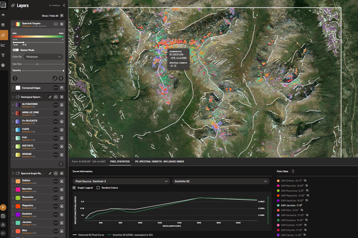
6. DEM-based Edge extraction
TerraEye applies an automated edge extraction workflow using Digital Elevation Model (DEM) data to extract subtle linear features—faults, folds, and lithological boundaries—that often control mineralization.
This process delivers a detailed edge map in minutes across an entire AOI, replacing weeks of manual mapping. By integrating these extracted edges with spectral and mineralization datasets, exploration teams gain an immediate, high-resolution view of the geological framework, enabling more accurate targeting and prioritization of follow-up work.
How technology enhances results:
- Subtle topographic expressions reveal geological controls that often influence mineralization
- Focuses exploration on zones dictated by geology rather than random surface variability.
- Enhances interpretation of spectral anomalies, providing a clearer structural context.
- Offers additional evidence supporting the presence of deposits, enabling confident prioritization of high-value targets.
High-Confidence Insights You Can Act On
- Cleaner, more reliable spectral layers feeding directly into AI spectral targeting
- Higher-confidence targets in partially exposed or challenging terrain
- Clear data notes on quality, surface exposure limits, and guidance on where field verification is most effective
- Actionable target maps that are easy to trust, defend, and integrate into exploration planning
These advanced preprocessing technologies transform raw spectral data into real-world exploration insights, ensuring your targets are driven by geology, not surface artefacts, and ready to guide efficient field decisions.